Friday, December 30, 2022

Local Paper Maps: Printing Them

This post is part of a series on creating and using local printed maps. Start here.

Hitting print on a USGS 7.5 minute map in Chrome brings up no good options for producing a hard copy. Sure, you can 'fit to page', but doing so results in a squished map.

The USGS, however, offers an elegant solution in their tutorial: Lesson 8b - Printing US Topos. If you open the PDF in Adobe Reader and hit print, you can choose the 'Poster' option. Doing so will result in the document being printed as a series of tiles, one per page, that as the name suggests could be taped together to form one large poster.

This is a clever way to print out the map and have it remain at its intended size. This is especially important because it results in a map that can be used with standard UTM map measuring tools. For example, the ones provided over at MapTools.com. Here's a page from a poster printed map with a Map Tools grid overlay:

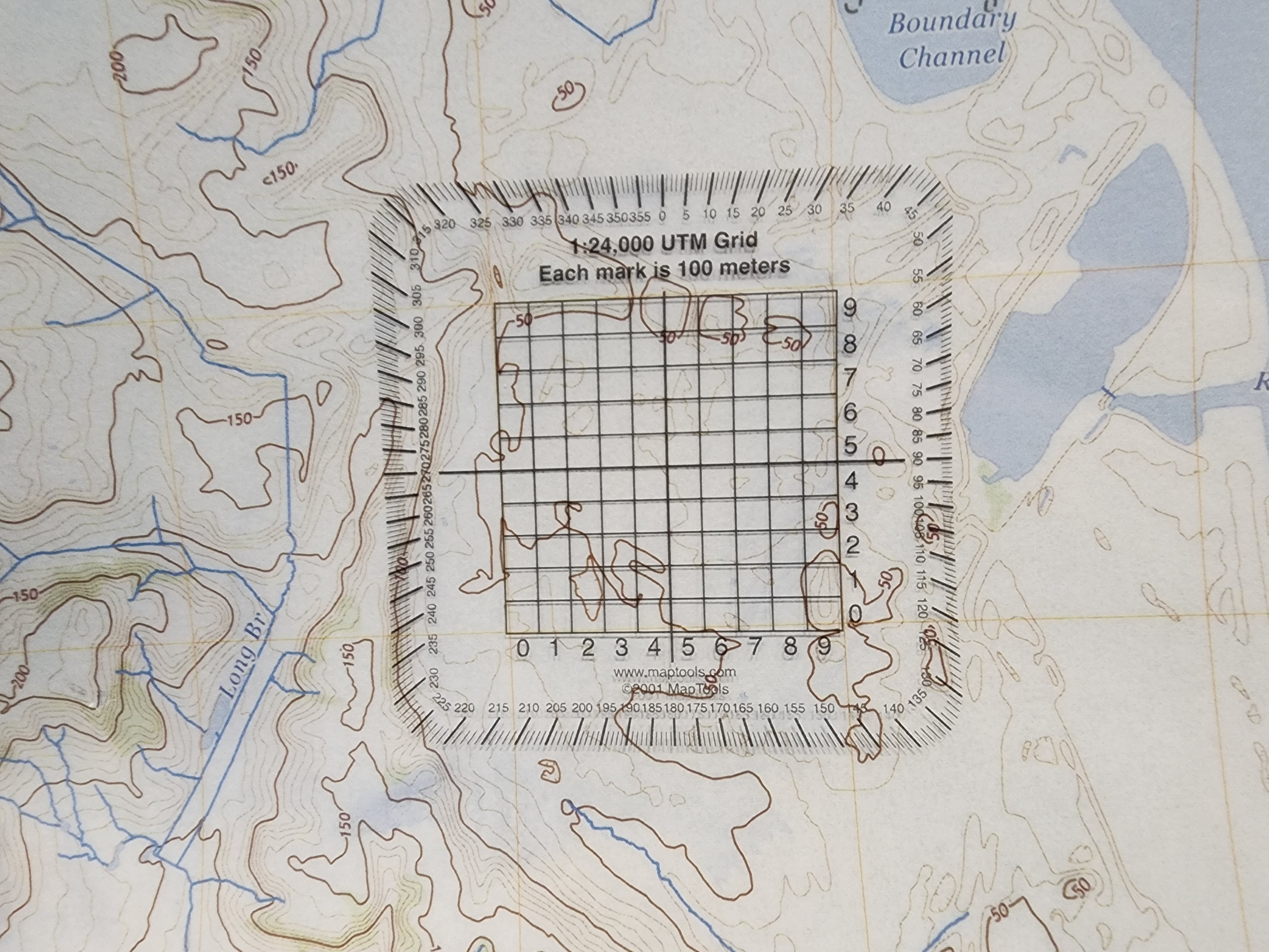
This grid vastly simplifies the process of pinpointing GPS locations on a physical map. Check this tutorial out to see what I mean.

One optional step is to poster-print the map to a PDF file. This results in a 9 page PDF file that can be opened and printed accurately using any PDF reader. This is handy if you're only interested in one tile or page of the map. For example, to experiment with navigating and annotating around my local neighborhood, I may print 5 copies of page 3 of this posterized PDF.

If you're interested in just a part of the map, the USGS Tutorial suggests another option: take advantage of Adobe Reader's print 'Current View.' This will cleanly print the area you've zoomed into on the map:

After finding and preparing a topo-centric view of my neighborhood, I was able to print the map using the poster approach described above.

Now it's now time to get my 'Lewis and Clark' on and go exploring!

Friday, December 23, 2022

Local Paper Maps: Preparing Them

This post is part of a series on creating and using local printed maps. Start here.

Once I had my desired USGS 7.5 minute GeoPDF file downloaded, I assumed the next step was to print it. After all, a hard copy of the map is what this effort is all about. Surprisingly, the innocuously titled USGS tutorial, Lesson 8a - US Topos Created after June 2017, demonstrated one more step before printing. That is, selecting what info I'd like to include on the printed map.

Loading a GeoPDF in Chrome or Apple's Preview, my default PDF viewer on Windows and Mac respectively, I see what I'd expect to see: a detailed USGS 7.5 minute map.

Following the USGS Tutorial, however, required that I download the Adobe Acrobat Reader. Once the industry standard, I haven't relied on Reader in years. Still, I took the time to set it up, including uninstalling the McAfee extras I didn't want, and was richly rewarded. Adobe's PDF reader, unlike most (but not all all), includes support for toggling layers. The USGS has packaged their maps as a series of layers, which I could now control.

Say I wanted to print a driving-friendly map. In this case, I can turn off all the content except 'Transportation' and 'Hydrography'.

Or maybe I want a bird's eye view of the area. In this case, I can turn on the normally disabled 'Images' layer and turn off most of the other layers to avoid clutter.

My interest is creating a set of printed maps to practice back country navigation. To support this, I turned off all the layers except 'Terrain', 'Hydrography', 'Wetlands' and 'Projection and Grids'. The result is impressive: suddenly I'm holding a view of my local area that is solely based on natural features. It's like I've been transported back in time hundreds of years and I'm encountering a pristine wilderness.

With my map prepared, now it really is time to hit the print button; That's next!

Sunday, December 18, 2022

Local Paper Maps: Finding Them

This post is part of a series on creating and using local printed maps. Start here.

As I mentioned in my opening post on this topic, finding local US maps is relatively straightforward. Head over to the USGS and download a freely available 7.5 minute quadrangle for your area of interest. In practice, there are some steps you can take to vastly streamline this process.

First off, you should watch this USGS tutorial: Lesson 4a – Using The National Map Download Application. When I initially saw 'download application' I imagined some crufty Windows program I would have to download to access maps. But that's totally wrong; the 'download application' is merely a straightforward webapp.

One point of confusion is that the USGS has a number of websites that offer map downloading capability. There's this slick site let's you explore both modern and historic maps. You can fiddle with the opacity of the maps to visualize different eras in one view.

And then there's the National Map Viewer, which allows you to visualize different layers of map data, as well as measure distances, elevations and overlay data sets on a map.

However, if you're interested in downloading maps, you really want to make your way to this relatively basic looking downloader site. This site has two useful tricks up its sleeve to help us in the local maps department.

First, you can opt to show just 7.5 minute topo maps, the type we're after. Next, you can opt to show just recent versions, which cuts down on having to wade through multiple years of these maps. In this screenshot I'm asking for the USGS to tell me which up to date topo maps define the area that is the DC Beltway.

The other notable feature of this site is that once you see a list of maps, you'll see both download links and the ability to add the items to a cart. If you're downloading a single map, by all means click the download link. But in my case, I've got 20 different maps to download. Rather than add them one-by-one to the cart, I can click the relativey subtle 'txt' link provided:

Doing so will download a text file where each line contains a URL to a single map. It's then trivial to use a tool like wget to download these files in bulk. Note: the downloaded text file has DOS style end of lines, so the first order of business to use this file on Linux was to strip these.

$ dos2unix data.txt
dos2unix: converting file data.txt to Unix format...
$ cat data.txt
https://prd-tnm.s3.amazonaws.com/StagedProducts/Maps/USTopo/PDF/VA/VA_Alexandria_20220927_TM_geo.pdf
https://prd-tnm.s3.amazonaws.com/StagedProducts/Maps/USTopo/PDF/VA/VA_Annandale_20220929_TM_geo.pdf
https://prd-tnm.s3.amazonaws.com/StagedProducts/Maps/USTopo/PDF/VA/VA_Fairfax_20220927_TM_geo.pdf
https://prd-tnm.s3.amazonaws.com/StagedProducts/Maps/USTopo/PDF/VA/VA_Falls_Church_20220930_TM_geo.pdf
https://prd-tnm.s3.amazonaws.com/StagedProducts/Maps/USTopo/PDF/VA/VA_Fort_Belvoir_20220929_TM_geo.pdf
https://prd-tnm.s3.amazonaws.com/StagedProducts/Maps/USTopo/PDF/VA/VA_Mount_Vernon_20220929_TM_geo.pdf
https://prd-tnm.s3.amazonaws.com/StagedProducts/Maps/USTopo/PDF/VA/VA_Occoquan_20220929_TM_geo.pdf
https://prd-tnm.s3.amazonaws.com/StagedProducts/Maps/USTopo/PDF/DC/DC_Anacostia_20191202_TM_geo.pdf
https://prd-tnm.s3.amazonaws.com/StagedProducts/Maps/USTopo/PDF/MD/MD_Beltsville_20191202_TM_geo.pdf
https://prd-tnm.s3.amazonaws.com/StagedProducts/Maps/USTopo/PDF/MD/MD_Brandywine_20191122_TM_geo.pdf
https://prd-tnm.s3.amazonaws.com/StagedProducts/Maps/USTopo/PDF/MD/MD_Kensington_20191205_TM_geo.pdf
https://prd-tnm.s3.amazonaws.com/StagedProducts/Maps/USTopo/PDF/MD/MD_Lanham_20191121_TM_geo.pdf
https://prd-tnm.s3.amazonaws.com/StagedProducts/Maps/USTopo/PDF/MD/MD_Laurel_20191202_TM_geo.pdf
https://prd-tnm.s3.amazonaws.com/StagedProducts/Maps/USTopo/PDF/MD/MD_Piscataway_20191122_TM_geo.pdf
https://prd-tnm.s3.amazonaws.com/StagedProducts/Maps/USTopo/PDF/MD/MD_Rockville_20191202_TM_geo.pdf
https://prd-tnm.s3.amazonaws.com/StagedProducts/Maps/USTopo/PDF/MD/MD_Seneca_20191122_TM_geo.pdf
https://prd-tnm.s3.amazonaws.com/StagedProducts/Maps/USTopo/PDF/MD/MD_Upper_Marlboro_20191121_TM_geo.pdf
https://prd-tnm.s3.amazonaws.com/StagedProducts/Maps/USTopo/PDF/VA/VA_Vienna_20190829_TM_geo.pdf
https://prd-tnm.s3.amazonaws.com/StagedProducts/Maps/USTopo/PDF/DC/DC_Washington_East_20191202_TM_geo.pdf
https://prd-tnm.s3.amazonaws.com/StagedProducts/Maps/USTopo/PDF/DC/DC_Washington_West_20191122_TM_geo.pdf
$ for u in $(cat data.txt) ; do wget $u; done
...

I've now got my maps. Next up: preparing them for printing.

Wednesday, December 14, 2022

Finding, Printing and Using Paper Local Maps

This Reddit discussion and this YouTube video inspired me to brush up on my old school map and compass skills. While figuring out where I could find the time to do this I had an epiphany: I didn't need to be exploring the backcountry to practice reading terrain or shooting azimuths; I could do all this in my own neighborhood. An no, I didn't need to buy a fancy compass either, the one built into my phone would be more than adequate. All I really needed was a high quality paper map of my local area.

A bit of Google'ing provide an easy answer to where I might find such a map. The USGS has been publishing local maps of the US since 1947. Using the USGS topo viewer, I plugged in my address and downloaded the 2022(!) Alexandria, VA 1:24000 quadrangle. I couldn't help but celebrate how smoothly my plan was coming together: I'd be practicing my orienteering skills in no time.

The map files are distributed as GeoPDFs, which means they can be opened and printed from any PDF reader, so that's what I did. As I grabbed the map from the printer I realized just how flawed my plan had been: the map was there, but it was scaled down to an unreadable level. As a local navigation tool, it was useless.

A quick Google Search suggested I wasn't the only one who had this problem, and offered these National Geographic maps as a solution. This was promising, as these were USGS maps and were designed for printing on letter sized paper. But there was a significant catch: many of these maps are now quite dated. For example: the Alexandria, VA quadrangle is from 1983. Considering the USGS has an update map from last year, it seemed silly to rely on National Geographic's ancient version.

I looked around for other solutions, but ultimate did the unthinkable: I read the manual. Or rather, I watched the Using the National Map Products and Services playlist on YouTube. These videos take you through viewing, downloading and yes, printing USGS maps. I watched them at 1.5x speed, and they were more than worth my time. In fact, I'd argue that if you spend any time in the outdoors or ever glance a map, it's worth taking the time to watch these videos.

In the next few posts I'll walk through each of the lessons I learned that let me ultimately produce local hard copy maps that exceeded my expectations. Up next: finding local maps.


See Also

Tuesday, December 13, 2022

Review: Outlander

Warning: Spoilers ahead. Proceed with caution.

The audio book version of Diana Gabaldon's Outlander is, well, long. It's just over 32 hours in length. I feel like I spent nearly that entire time trying to make sense of Gabaldon's work. What exactly was I listening to?

When the story opened I had truly no expectations. When the main character, Claire, jumped back into the 1700's I thought: Aha! it's a time travel book. Cool!

I was psyched that Claire jumped into Scotland during the 1700's, as one of my favorite YouTube channels explores this time period in depth. I thought I was in store for some historic fiction. Which I was. Mostly.

The book seemed to take another turn when Claire was forced to marry Jamie. Ahhh, young, muscular, fit, handsome, honorable, lovesick, and notably sexually inexperienced Jamie. That's when I thought the true colors of Gabaldon's work were revealed: it was a sort of ladies escape fantasy.

Why else would Claire and Jamie have so much sex? There were so many scenes and with so much detail that I found myself losing patience and hitting the 10-second skip button whenever things got steamy. But it's not just all the hanky panky: Claire seamlessly adjusts to life in the 1700's and her World War II nursing experience let's her play a meaningful role in the community. Most importantly, she finds safety and camaraderie among the McKenzie Clan, tucked away in an idyllic castle no less.

So this must be what the ladies want, I thought to myself as I listened to Claire flourishing in her new life.

To Gabaldon's credit, she doesn't let the text linger in this blissful state for long. As detailed as the sex scenes are, so too was Claire's brutal introduction to the domestic violence that was the norm of the 1700's. Add to that lengthy and vivid discussions of corporal punishment, the injustice of a witch trial and the ultimate torture and rape of Jamie and I found myself asking: just who is this book written for? These are powerful and uncomfortable topics, and for Gabaldon to take them on at the same detail that she tackles the romance of Claire and Jamie is both jarring and I suppose impressive.

I can almost imagine the interaction between Gabaldon and say her 4th grade teacher when she handed in her first story. "It's nice," the teacher might have said, "but it could use more detail." At which point, Gabaldon was like, you want detail? I'll give you detail! And before you know it, folks like myself are muttering: "I get it, I get it" and pressing the skip button repeatedly to avoid yet another intimate encounter between Claire and Jamie.

So is Outlander erotic fantasy? I think classifying it as such is missing the mark. Ultimately Gabaldon wants to reveal life in the 1700's, and heck, life itself, as what it is: sometimes magnificent; sometimes horrifying. Most importantly, she's not in hurry and will gladly bring the TMI.

Apparently there are eight more books in this series. After the long journey of book one I'm a bit hesitant to start book two. However, I'm guessing I'll watch a clever video put out by Fadbai Dozi, and I'll once again yearn for a bit of Scottish Highlander storytelling. And then I'll be ready to catch up with Claire and Jamie.

Monday, December 12, 2022

Let There Be Upcycled Light

Over the weekend I found myself with a couple of tablespoons of vegatable oil that had served its purpose and couldn't be reused for cooking. Not long ago, I'd have chucked the oil in the trash without a second thought. Thankfully I am now more enlightened and empowered, and have the option to add it to our weekly food scrap collection bin. Instead of taking that route, I poured the oil into a stray glass container I'd been holding onto because of its unique shape.

I then added and lit a Chanukah inspired floating wick:

Voila! Light!

None of this is breaking new ground: lamp wicks and vegatable oil based fuel are readily available on Amazon and have been burned for millenia. Still, I'm glad that I: (a) made the connection between food and fuel, and (b) appreciated that in a blackout, that box of wicks would be awfully helpful, (c) was able seize an upcycling opportunity.

Friday, December 09, 2022

Laptop Trackpads Are Awful. AutoHotKey Makes Them Better.

Back in the day*, here's what a laptop trackpad looked like:

They had the familiar space to position your screen's cursor, and two physical buttons to send a left and right mouse click.

Fast forward today, here's what a modern trackpad looks like:

No doubt inspired by Apple's minimal aesthetic, the trackpad is now larger and the physical buttons have been removed. To left and right mouse click you simply press on the left or right hemisphere of the trackpad. Better, right?

In my experience, not so much. Because I keep my eyes on the screen and there's no tactile feedback as to the placement of my fingers, I find that I regularly click on the wrong side of the pad. Every time this happens I have to: (1) curse modern trackpads and (2) reset the position of my hand and click again. It's maddening.

To add insult to injury, some of the laptops I use require just a bit too much force to trigger a mouse-click. After a day of using these laptops, my digits are sore from all the pressing.

Thankfully, AutoHotKey can fix this mess. Here's how:

#SingleInstance,Force

;; 1. Make: Right Mouse Button send a Left Mouse Click
RButton::LButton

;; 2. Make: Win + Left Mouse Button send a Right Mouse Click
#LButton::RButton

;; 3. Make: Win + Right Mouse Button send a Right Mouse Click
#RButton::RButton

;; 4. Make: Win + Space send a Left Mouse Click
#Space::
MouseClick
return

;; 5. Make: Ctrl + Win + Space send a Right Mouse Click
^#Space::
MouseClick right
return

Commands (1), (2) and (3) re-work the logic of clicking on the trackpad. Now, any press anywhere on the trackpad sends a Left-Mouse-Click. And if I hold down Win and press the trackpad it always sends a Right-Mouse-Click. This removes the need to respect an imaginary boundary and makes all presses on the trackpad be consistent.

Commands (4) and (5) remove the need to press the trackpad at all by making the Win + Space send a left or right mouse click. Every time I click like this, I feel like I've traded a fatigue inducing task for a press on the o'l Easy Button.


*Photos courtesy of a recent laptop recycling effort.

Tuesday, December 06, 2022

Taming The Moby Wrap

One of my go-to pieces of baby gear is the Moby Wrap baby carrier. I've used it to soothe and schlep countless little ones. From miles of laps around the first floor of our home, to the jungles of Belize, the Moby has been a constant and reliable companion.

To underscore its utility and effectiveness, I'm composing this blog entry at my standing desk with baby L softly snoring away in the Moby.

One challenge with the Moby is that its roughly 900 feet of cotton fabric can make it unwieldy to don. At home, with practice, this turns out to be easy enough to do. But in more hostile territory, say a parking lot, airport or trail head, keeping the fabric off the ground can be a chore.

After over a decade of tripping over this problem, I finally found a simple solution. I stuffed each end of the wrap into mesh reusable produce bags:

Once in this configuration, I had essentially two separate rope bags. If I gently pull on either bag the fabric feeds out. If I stop pulling, the fabric stays put. The result is that I can effortlessly put on the Moby without the fabric flopping around everywhere.

I field tested this setup on our last vacation, and I was amazed at how seamlessly it worked. Putting on the Moby at various trail head parking lots was a breeze. I used this same arrangement again last night, putting the Moby (and baby!) on in the lobby of Shira's gym. Again the process was hassle free.

Hurray for little wins!

Wednesday, November 30, 2022

Abingdon Adventure - Day 3

After completing two iconic Virginia hikes, I was delighted when we had the opportunity to check off another. Like the previous trails, what they lacked in mileage was more than made up for in distinctiveness. Conveniently, the trail was located half-way between Abingdon, VA and the DC area, so it served as the perfect rest stop on our way home.

The trail was none other than the Blue Ridge Tunnel. The Blue Ridge Tunnel, as the name suggests, is a hike whose primary feature is that you make your way through a railway tunnel. But this isn't just any tunnel, it took 8 painstaking years to create and was completed in 1858. At that time, its length of 4,237 feet made it the longest tunnel in the United States. Because it predates dynamite and heavy machinery, it remains the longest tunnel in the US built using hand tools and black powder.

So this isn't just a hike through a tunnel; it's a hike through history.

The most stunning statistic I've read about the tunnel is this: 26 feet. That's the average number of feet per month that were excavated on each side. (In 1851, just 19 feet a month were blasted on the east side!). That seems glacial considering the hundreds of men working on the project.

This article from the Richmond Daily Dispatch summarized the state of affairs 3 years into the project:

The Blue Ridge tunnel

We have recently heard many inquiries made as to the condition and prospects of the Blue Ridge Tunnel, and the likelihood of its being completed within the present century. We are unable to give our readers any precise information on the subject. The rock at which Col. Crozet is tapping is not exactly as accessible as a "hollow beech tree." Its flinty heart refuses to be enforced or entreated. ... The contest between the iron and the rock is wearing out the iron, while the rock shows little sign of suffering. ... People complain that Col. Crozet does not go through the mountain. Col. Crozet, no doubt, would be glad to do so, but the mountain will not let him. To those who insist that Col. Crozet shall be removed, we reply that they would better undertake to remove the mountain, which seems to deserve it, on account of its in hospitable treatment of Col. Crozet and the Commonwealth of Virginia.

Who knew newspaper's of the 1850's could be so snarky? I'm impressed!

Success finally came late in 1856 when the two sides of the tunnel met and were mere inches off:

On Monday morning last, at an early hour, the workmen in the western end of the Blue Ridge Tunnel perforated hole, about two inches in circumference, through the mountain, and, in tho language of Gen. Gordon, "daylight now shines through the blue Ridge." This event caused great joy on the part of the workmen, and every one of them immediately laid down their tools to spend the rest of the day in a frolic.

So accurately had been all the calculations made by Col. Crozet, that the augur holes from both ends of the tunnel were only half an inch distant from each other, when they met, and the length of the tunnel as computed by measurement on the outside, over the top of the mountain, and as accurately measured inside, after the perforation, was less than six inches.

Even with this success, it would take nearly two more years for the tunnel to be opened.

We parked our car at the eastern trail head, and walked the .6 miles of flat terrain to the entrance of the tunnel. The sun was out and we had baby L in the stroller. Approaching the tunnel, the conditions dramatically changed as we found ourselves in the shade of the mountain and cold air pouring from the mouth of the tunnel. We took countless pics at the opening and then made our way inside.

We could see the light at the end of the tunnel, and as promised it was pitch black and quite chilly inside. It was also fairly busy, with many families taking advantage of the hike as a post Thanksgiving activity. So as ominous as the pitch black tunnel was, the mood remained jovial.

Shira and baby L, now out of her stroller an being snuggled by Shira, went as far into the tunnel as to be in total darkness. Shira then had her fill and returned to the sunshine outside. I went deeper, though I didn't make it as far as the western entrance.

Over all the experience was a worthy one and I highly recommend this hike. Hopefully we'll be back in the area in the future, minus an 8 week old, and I'll be able to convince Shira to walk the entire length of the tunnel.

Tuesday, November 29, 2022

Abingdon Adventure - Day 2

What drew us to the Abingdon Virginia area, and our plan for today, was to summit Mount Rogers, the tallest peak in Virginia. But we had a small disruption to our plans. By small, I mean an adorable 4 week old foster placement. I'm all for taking little ones hiking, but even I thought attempting 9+ mile trek with possibly winter conditions and a reduced window of daylight was a bad idea.

Ultimately, we kept Abingdon as our Thanksgiving adventure destination and brought baby L along with us. We decided to hike in the Mount Rogers area, but scaled the hike to something a bit more child friendly. This article suggested that the 4 mile, out and back, Wilburn Ridge Trail would be a good fit for us. While the AllTrails description and reviews were lackluster, we trusted GoHikeVirginia.org and were richly rewarded.

The specs on the trail were basic: proceed 2 miles North on the Appalachian Trail, followed by 2 miles back. Thankfully, that terse description doesn't begin to do the trail justice. For one thing, because of the unique bald ecosystem, there's no dense tree cover to obstruct views. Everywhere we looked we saw postcard-perfect vistas. In the summer, the lack of shade is no doubt a hinderance. But on our 55° and sunny day, the open area was perfect. And then there are the famous Grayson Highlands State Park Ponies.

When we've seen wild horses in the past, we were quite content to keep our distance. But these ponies, my gosh, are judiciously adorable. The group we found was interested in little more than munching grass and letting us photograph them. While the signs in the area insist that you don't touch them (they bite and kick!), of course, people were petting them. But at least nobody was feeding them. We spent quite a bit of time photographing the ponies and they were definitely the highlight of this hike.

After having a picnic lunch we continued up to Wilburn Ridge, enjoying the slightly technical trail. One or two reviews on AllTrails suggested there was some rock scrambling to be done on this trail, something I wasn't prepared to do with an 8 week old baby strapped to my chest. Thankfully those claims were over-sold. There were a couple of spots that required some extra care while maneuvering, but I'd hardly call them scrambling. Near the turn-around point there was a cool rock tunnel thing you walk through, and because it's in the shade, it was filled with ice. But even that was more fun than scary. On the return trip, out of an abundance of caution, we took a side trail around the rock tunnel.

Oddly, the hike appears to turn around in sight of a rocky summit. If we'd had older kids with us, I'm sure we would have attempted that last burst of elevation. We would have also explored the countless rock-piles we saw along the way. Baby L and Shira were happy at the turn around point, so I took the win and kept the hike as the parameters described by AllTrails.

The Wilburn Ridge via Appilachian Trail is a great example of a hike where the quality exceeds its quantity. Sure, it's only 4 miles and on paper doesn't look like much. But in-person, the combination of the unique bald environment, amazing views and ponies made it a real winner.

After our hike and a stop back in Abingdon, we headed out for an evening adventure: viewing the Bristol Motor Speedway Lights. The Speedway is in Tennessee, and while it's no longer running NASCAR races for the season, it is open for a holiday light display.

The grounds of the speedway were lit up with an impressive number of light displays. And it was sweet to get to drive both on the drag-strip as well as inside the concourse of the stadium. But the real highlight was the moment when we drove onto the race track itself. We entered on one of the crazy steep banked sides, and the what-the-heck look on Shira's face was priceless. We then got to do a lap around the track. Mind you, our lap time was just a tad bit slower than the 150 Mph record set back in 2011, but it was still a thrill to be up close and personal to such a unique venue.